
Helping Local Governments Protect Water Resources
References for communities looking to protect aquifers, lakes, rivers and streams
Links for the resources described in a presentation in Elmira, New York on February 22, 2013.
Aquifer Maps and Diagrams
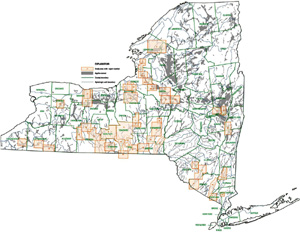
Map of Primary and Principal Aquifers in NYS
Figure 2.1 of the Revised Draft SGEIS, page 2-21. Click here for PDF of Figure 2.1. Primary aquifers are defined as "highly productive aquifers presently utilized as sources of water supply by major municipal water supply systems." Principal aquifers are "aquifers known to be highly productive or whose geology suggests abundant potential water supply, but which are not intensively used as sources of water supply by major municipal systems at the present time." See http://www.dec.ny.gov/lands/36119.html.
Closeup of Our Area
Closeup showing that eleven of New York's 18 primary aquifers are located in our area.
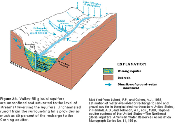
Cross-section of the Corning Valley Fill Aquifer
The diagram illustrates how the Corning valley fill aquifer is incised into the bedrock. Figure 28 from Surficial Aquifer System, Valley-Fill Glacial Aquifers, Ground Water Atlas of the United States, USGS publication HA 730-M, http://pubs.usgs.gov/ha/ha730/ ch_m/M-text1.html. "The Corning aquifer is an example of a valley-fill glacial aquifer deposited by meltwater streams that drained away from stagnated or melting glacial ice in upland valleys. It is characteristic of many such glacial-drift aquifers in the Appalachian Plateaus. The aquifer occupies four deeply incised bedrock valleys formed by the junction of the Chemung River and its principal tributaries, the Canisteo, the Tioga, and the Cohocton Rivers, in southeastern Steuben County, N.Y. The valleys are incised deeply into flat-lying shaly carbonate bedrock."
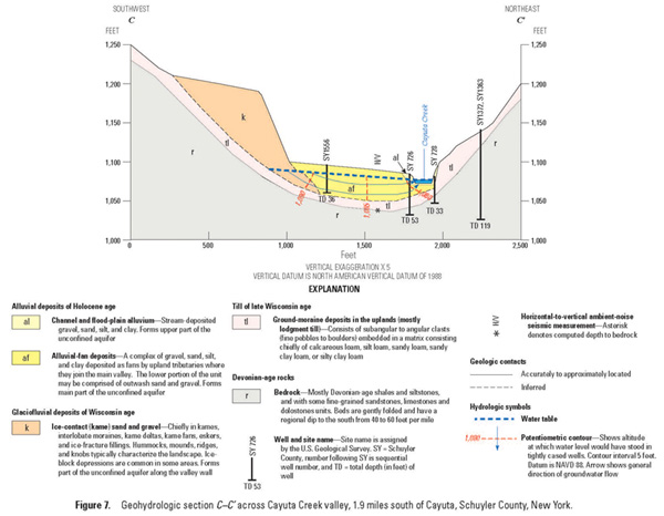
Cross-section of the Cayuta Creek Aquifer
Figure 7, Geohydrologic section across Cayuta Creek Valley, from the recently released USGS study of the aquifers in the valley, "Hydrogeology of the Stratified-Drift Aquifers in the Cayuta Creek and Catatonk Creek Valleys in Parts of Tompkins, Schuyler, Chemung, and Tioga Counties," New York, 2012, Miller, Todd S.; Pitman, Lacey M., USGS Scientific Investigations Report: 2012-5127, http://pubs.er.usgs.gov/publication/sir20125127
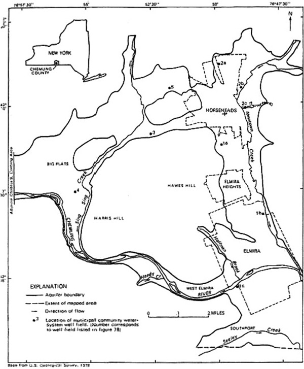
Map of the Elmira-Horseheads-Big Flats Aquifer
From Chapter Seven, Elmira-Horseheads-Big Flats Area, Figure 7A, T.S. Miller, 1982, in Atlas of Eleven Selected Aquifers in New York, R.M. Waller and A.J. Finch, eds., U.S. Geological Survey Water-Resources Investigations Open-File Report 82-553, p. 127 et seq. Download PDF of Chapter 7 at http://www.horseheadsdistrict.com/uploadeddocs/ AquiferStudyAppendix.pdf.
Many Aquifers Are Not Mapped in Detail
Map showing which aquifers in New York have been mapped in detail by USGS. See http://ny.water.usgs.gov/projects/bgag/ aquifer.maps/aquifer1.maps.html. John H. Williams, USGS Groundwater Specialist, testified to the NYS Assembly hearing on the DEC's proposed fracking regulations, January 10, 2013, that "the valley fill aquifers found in upstate New York are some of the most important aquifers in the state." He noted that detailed aquifer maps are available for many aquifers in the Southern Tier, but said that approximately 375 miles of valley fill aquifers have not been mapped at a detailed level and, "Thus a substantial portion of the area with the highest potential for shale gas development lacks the basic hydrogeologic information needed to assess these aquifers, including their spatial extent." See http://www.youtube.com/ watch?v=WjuXg9f7jVU, testimony beginning at 10:10. The testimony quoted is one of his first remarks. Mr. Williams' testimony on this issue was highlighted by Assemblyman Steve Englebright, himself a geologist, when he questioned DEC Commissioner Martens on Feb. 4, 2013, during the Assembly Budget hearing. See http://www.youtube.com/watch?v=IDNm9wfFsUc#t= 2h21m at 2:24:40. Mr. Martens responded that all New York's primary and principal aquifers have been mapped in sufficient detail. A comparison of the map on the left with the primary and principal aquifer map above demonstrates that a majority of the principal aquifers in the state have not been mapped. The DEC website states that "All of the Primary Aquifers have been mapped in detail at a scale of 1:24,000." See http://www.dec.ny.gov/lands/36119.html. As is seen in the aquifer map on slide 1 above, primary aquifers are only a small fraction of the total number of aquifers in New York.
Maps of Surface and Groundwater Monitoring Locations
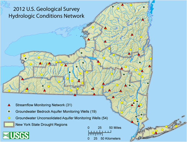
Map of USGS Hydrologic Conditions Network
Showing USGS groundwater and streamflow monitoring locations from DEC webpage on Drought, http://www.dec.ny.gov/lands/5011.html. The page states: "The NYSDEC and USGS are partners in evaluating hydrologic conditions across New York State. Data evaluated includes stream discharge, water levels, precipitation, and components from water-quality monitors. This information and additional information from other Federal, State, and local agencies assist the NYSDEC and the State Drought Management Task Force in evaluating regional conditions for determination of drought classifications. The USGS maintains tables and reports of current hydrologic conditions (link in the right column). The map shows the latest Hydrologic Conditions Network, which includes monitoring wells and stream gauging stations."
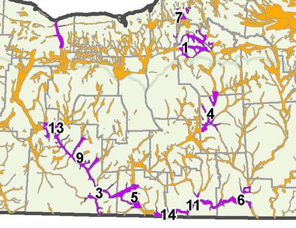
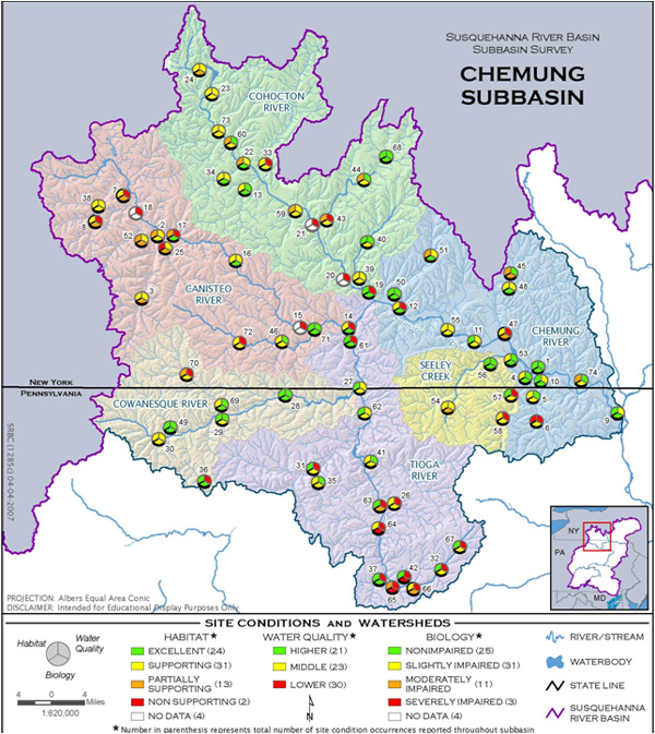
SRBC Stream Monitoring Sites in Chemung Subbasin
Site Conditions and Watersheds Map from the Susquehanna River Basin Commission's Chemung Subbasin Atlas Maps, Current Projects: Chemung Subbasin Survey, http://www.srbc.net/atlas/ chemungSubbasinSurvey.asp. The SRBC's 2006 Chemung Subbasin Survey of water quality can be downloaded at http://www.srbc.net/pubinfo/ techdocs/Publication_251/techreport251.pdf. The DEC's most recent Chemung River Basin Waterbody Inventory/ Priority Waterbodies List Report was issued as a Final Draft Report in May 2007. This report includes an overall evaluation of water quality in the Chemung River Basin, as well as assessments for specific waterbody segments in the basin. It is linked at http://www.dec.ny.gov/chemical/36746.html. A 2003 report on Ground-Water Quality in the Chemung River Basin, New York, by Kari K. Hetcher-Aguila, USGS Open-File Report 2004-1329 is posted at http://ny.water.usgs.gov/pubs/of/of041329/.
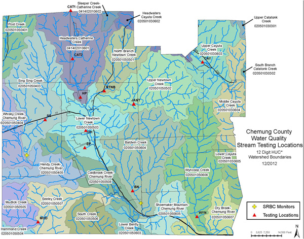
Chemung County Water Quality Committee Surface Water Monitoring Sites
The types of data collected by the committee are described at http://chemungcounty.com/index.asp?pageId=406
The Chemung County Water Quality Strategy Plan is linked at http://www.stcplanning.org/index.asp?pageId=40
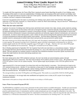
Annual Drinking Water Reports
Annual Drinking Water Quality Reports
Information about public drinking water supplies is available in the Annual Water Quality Reports that public drinking water systems are required to provide. The purpose of the AWQR reports is described on the NYS DOH website at http://www.health.ny.gov/environmental/water/drinking/ annual_water_quality_report/: "The Annual Water Quality Report is designed to provide consumers with information on the quality of the water delivered by their public water system. Annual Water Quality Reports must contain information about the water system; information on the source of the water; reporting levels of contaminants detected in the finished water; information on cryptosoridium, radon, and other unregulated contaminants; information on any violations of the national primary drinking water regulations; and information regarding any variances or exemptions the water system may be operating under. . . . Public water supplies serving greater than 100,000 people are required to post their Annual Water Quality Reports on the internet. For all other Annual Water Quality Reports, contact your local health department, Department of Health District Office or public water supplier."
The Environmental Working Group has a summaries of 2004-2008 data for every zip code in their National Drinking Water Database, http://www.ewg.org/tap-water/
Examples of Using Zoning to Create Aquifer Protection Districts
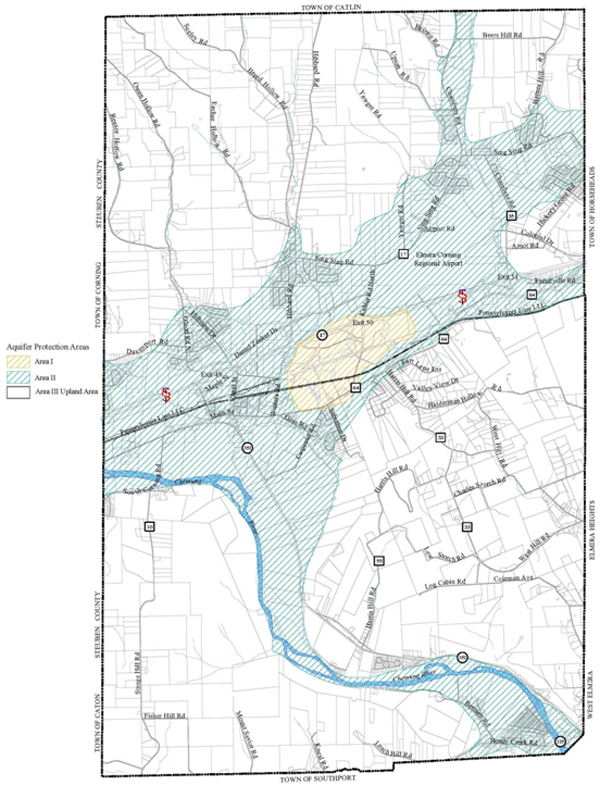
Map of Aquifer Protection District, Town of Big Flats, New York
The map is posted at http://www.bigflatsny.gov/ uploads/Main/Town_Aquifer_Protection_Zone_Map.pdf. The Big Flats ordinance creating the aquifer is posted at http://landuse.law.pace.edu/landuse/ documents/ laws/reg2/LandUseCenter5.doc. The Big Flats Comprehensive Plan describes the district: "The Aquifer Protection Overlay District (APOD) is intended to preserve the quality and quantity of the town’s groundwater resources to ensure a safe drinking water supply. The district has three areas that are overlaying other districts, Area I, Area II, and Area III. Area I is described as the area of the aquifer that is highly permeable and primarily serves as a public water supply for a municipal water system. Area II is the area of the primary aquifer, which, although it may potentially be a productive water source, is not yet used intensively as a public water source. Area III is the upland area of the town tributary to the aquifer protection overlay district. The APOD provides a list of certain prohibited uses, and in addition gives the Planning Board, through the site plan review process, the authority to request additional information from professional hydro-geologists or other experts for certain potentially harmful commercial and industrial uses proposed within the APOD." See http://www.bigflatsny.gov/uploads/Govt/ Big_Flats_Comprehensive_Plan.pdf, page 32.
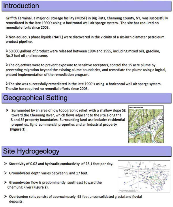
Remediation of a Petroleum Spill in Big Flats, New York
Section of a poster describing the remediation of a petroleum spill at the Griffith Oil Terminal in Big Flats, New York, showing the geographical setting near the Chemung River. Poster linked at http://www.directionaltech.com/post- closure- analysis-proves-success-of-enhanced-hydrocarbon-bioremediation- using-twelve-horizontal-sparge-wells-at-petroleum-products-bulk-terminal/. The Town of Big Flats Hazard Mitigation Plan mentions a major petroleum spill event at Griffith Oil Terminal. See http://www.stcplanning.org/usr/Program_Areas/ Hazard_Mitigation/BigFlatsHazardPlan.pdf
Local Laws other than Zoning
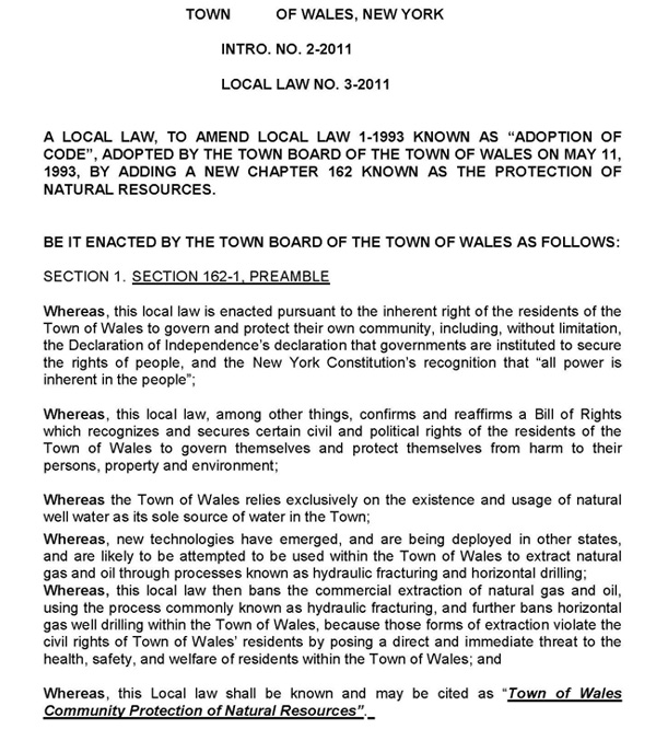
Town of Wales, NY Local Law adopted June 14, 2011
In addition to banning fracking, the ordinance protects water resources in the town and provides criminal penalties for its violation. The law is posted at http://documents.foodandwaterwatch.org/ doc/Frack_Actions_WalesNY.pdf. A CELDF Press Release describes the law: "The Ordinance ( No.3-2011) was enacted as a local law under NYS Municipal Home Rule Act, which recognizes broad police powers under the statute. The Ordinance establishes a Bill of Rights for Wales residents and “recognizes and secures certain civil and political rights of the residents of the Town of Wales to govern themselves and protect themselves from harm to their persons, property and environment.” See http://www.celdf.org/celdf-press-release-wales-ny-adopts-community-rights-ordinance-that-bans-fracking
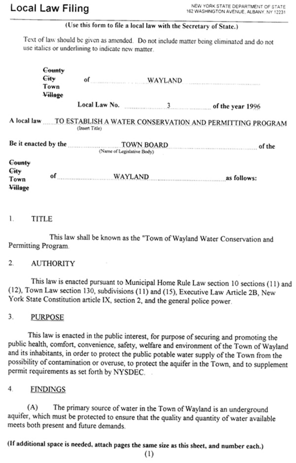
Town of Wayland, NY Water Conservation and Permitting Program
Local law adopted in 1996. Download from http://townofwayland.org/content/Laws/View/ 20:field=documents;/content/ Documents/File/23.pdf. The Findings section of the law states:
(A) The primary source of water in the Town of Wayland is an underground aquifer, which must be protected to ensure that the quality and quantity of water available meets both present and future demands.
(B) Groundwater quality samples taken from the former Wayland landfill have exceeded standard for some inorganic parameters established by NYSDEC for groundwater. Pressure reduction in the aquifer, and the increased gradient produced by additional pumping, might increase the downward and lateral migration rate of these contaminants, migration of these contaminants into the water supply could have a detrimental effect on water quality for wells within the flow path of the aquifer.
(C) After recent temporary increases in groundwater pumping, numerous residents of the Town of Wayland experienced one or more of the following conditions: ( 1) loss of water, (2) low water; (3) cloudy or muddy water; and (4) bad tasting and/or bad smelling water.
(D) The tax base of the Town will suffer adverse effects if water quality and/or quantity problems are not addressed in such a way as to protect future development, and the property values of existing residences and businesses.
(E) If water conservation and permitting programs are not instituted, irreparable damage may be done to the local aquifer; the local environment and property values in the Town.Critical Environmental Areas
New Yorks SEQRA regulations provide that local agencies may designate specific geographic areas within their boundaries as Critical Environmental Areas (CEAs). To be designated as a CEA, an area must have an exceptional or unique character with respect to one or more of the following: a benefit or threat to human health a natural setting, e.g., fish and wildlife habitat, forest and vegetation, open space, scenic quality agricultural, social, cultural, historic, archaeological, recreational, or educational values; or an inherent ecological, geological or hydrological sensitivity to change that may be adversely affected by any change. Following designation as a CEA, the potential impact of any Type I or Unlisted Action on the environmental characteristics of the CEA is a relevant area of environmental concern and must be evaluated in the determination of significance prepared pursuant under SEQRA. See http://www.dec.ny.gov/permits/6184.html.
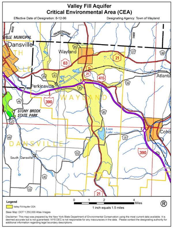
Map of Wayland Valley Fill Aquifer Critical Environmental Area
From http://www.dec.ny.gov/docs/permits_ej_operations_pdf/ valley.pdf. The Wayland CEA was established in conjunction with local water conservation and permitting law referenced above. According to the DEC website, the Wayland CEA is the only CEA in Steuben County, and there are no CEAs in Chemung County. A list of CEAs by County on DEC website at http://www.dec.ny.gov/permits/6184.html
Sole Source Aquifers
Map of Sole Source Aquifers in New York
Sole source aquifers are designated by the EPA pursuant to the Safe Drinking Water Act. A sole source aquifer is defined as one which supplies at least fifty percent (50%) of the drinking water consumed in the area overlying the aquifer. There can be no alternative drinking water sources that could physically, legally, and economically supply all those who depend upon the aquifer for drinking water. SSA designations are made in response to a petition from the locality, and after public hearing. All Federal financially assisted projects that have the potential to contaminate the SSA area are subject to review by the EPA. State and local governmental agencies may have to more closely scrutinize a project before granting a permit in an SSA. For example, the NY Environmental Conservation Law requires that any person seeking a SPDES permit or a renewal within an area designated as a sole source aquifer, shall include as a part of the required information, the name and address of all public water purveyors with a service area within three miles of the applicants facility. For more information about the EPA's Sole Source Aquifer Protection Program visit http://water.epa.gov/infrastructure/drinkingwater/ sourcewater/protection/solesourceaquifer.cfm
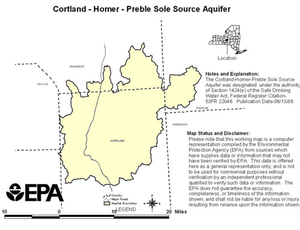
Map of the Cortland Homer Preble Sole Source Aquifer
The Cortland Homer Preble SSA was designated in 1988 in response to a petition from the Cortland County Legislature. The Cortland-Homer-Preble Aquifer System underlies portions of Cortland and Onondaga Counties, New York. It is the sole source of drinking water for the 35,000 residents in the aquifer service area; There are no viable alternative drinking water sources of sufficient supply; and if contamination were to occur, it would pose a significant hazard to public health. See Cortland Homer Preble Aquifer System, US EPA Region 2, http://www.epa.gov/region2/water/aquifer/cortland/ fr_cortl.htm#I9
Municipal Compacts and Watershed Associations
In 1960, the New York legislature authorized local governments to cooperate by entering into inter-municipal agreements for the performance of their respective functions, powers, and duties and allows them to cooperate regarding land use planning, regulation, and administration with the enactment of Article 5-G of the General Municipal Law. In 1993 the state legislature authorized county governments to assist constituent localities in land use matters. The 1993 amendments modified General Municipal Law §§ 119-u and 239-d, as well as General City Law § 20-g, Town Law § 284 and Village Law § 7-741. Pursuant to these amendments, a county planning agency can act in an advisory capacity, assist in the preparation of a comprehensive plan, assist in the preparation of land use regulations, and participate in the formation of individual or joint administrative bodies. For more information, see Grassroots Regionalism Under New York Law: Encouraging Intermunicipal Land Use Compacts, John R. Nolon, March 1999, http://digitalcommons.pace.edu/cgi/viewcontent.cgi?article=1177&context=lawfaculty.
Keuka Watershed Improvement Cooperative
The Keuka Watershed Improvement Cooperative (KWIC) was formed by inter-municipal agreement in 1993 of the six towns and two villages bordering Keuka Lake. The previous watershed organization known as the Keuka Lake Perimeter Committee became dysfunctional in the early 1980's after several towns pulled out of the agreement. The Keuka Lake municipalities determined that tourism and tax base depend on a clean and healthy lake. Local tourism generates nearly $50 million dollars a year, and the real property tax base along the lake represents an estimated $1 billion (up to 70% of all assessed value in many towns). For more information about KWIC, see http://keukawatershed.com/ and http://www.keukalakeassoc.org/how/wq_kwic_history.php
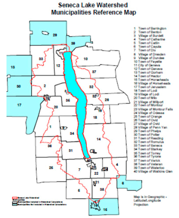
Proposed Seneca Lake Municipal Partnership
The Seneca lake Pure Waters Association (SLPWA) recently sent a letter sent to all the counties, towns, cities and villages bordering Seneca Lake suggesting the formation of an intermunicipal Seneca Lake watershed agreement. The letter states, "By actions taken or not taken within its boundaries, each municipality within the Seneca Lake watershed has an influence over the ecology and water quality of Seneca Lake and its tributaries. We believe that a partnership across all municipalities in the watershed dedicated to enhancing and preserving the quality of Seneca Lake would be in the long term interests of our communities and the Finger Lakes." See http://www.senecalake.org/
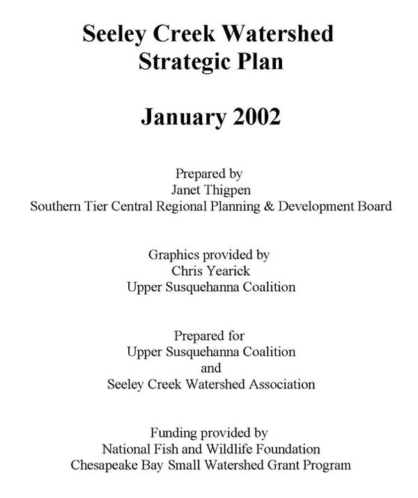
Seeley Creek Watershed Association
The Seeley Creek Watershed Association is comprised of citizens, elected officials, and government agencies working together in Pennsylvania and New York to improve water quality, reduce flooding, and conserve the natural resources of the Seeley Creek watershed.
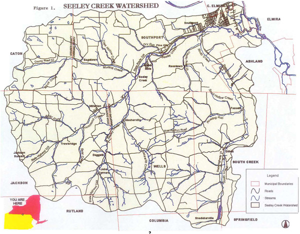
Seeley Creek Watershed Map
Figure 1 from Seeley Creek Watershed Strategic Plan, p. 2, showing towns and states in the watershed, http://www.stcplanning.org/usr/Program_Areas/ Environmental%20Planning/ Watershed_Plan_Seeley_2002.pdf.
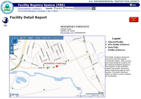
Facility Detail Report for McInerney Farm Hazardous Waste Site
From http://iaspub.epa.gov/enviro/fii_query_detail.disp_ program _facility? p_registry_id=110008086249. The McInerney Farm Hazardous Waste Site is discussed in the Seeley Creek Watershed Strategic Plan in the section on hazardous material releases in the watershed on page 47: "Hazardous contaminants are located within the Seeley Creek floodplain at the McInerny Farm Hazardous Waste Disposal Site in the Town of Southport. Although this site was remediated, subsequent monitoring has identified additional contamination."
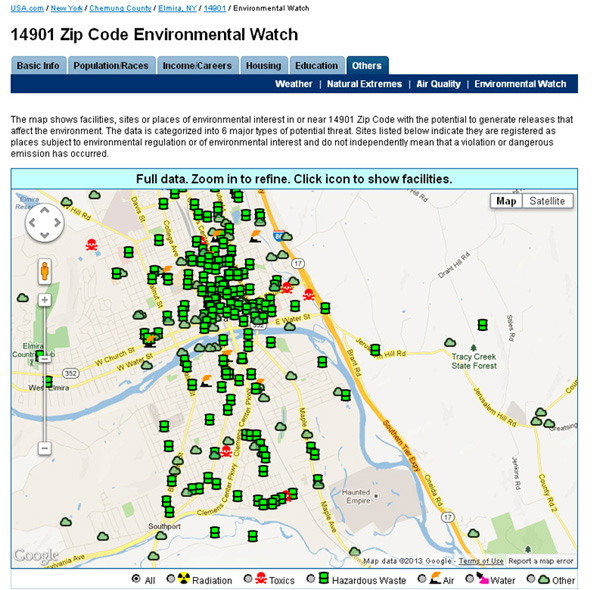
Hazardous Waste Sites in Elmira Zip Code
Map of facilities, sites or places of environmental interest in or near the 14901 Zip Code with the potential to generate releases that affect the environment from http://www.usa.com/14901-ny-environmental-watch.htm. The sites listed "indicate they are registered as places subject to environmental regulation or of environmental interest and do not independently mean that a violation or dangerous emission has occurred."
IMPORTANT LEGAL DISCLAIMER: These reference materials are published for educational purposes only. The matters discussed in the presentation are general in nature and are incomplete descriptions of the law. Nothing in this presentation constitutes legal advice or an offer of legal advice. You should contact your attorney to obtain advice with respect to any particular issue or problem.


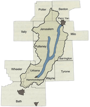
Hammondsport, New York 14840
607-569-2114, info at treichlerlawoffice.com
LLI Profile, Client Log-In